-
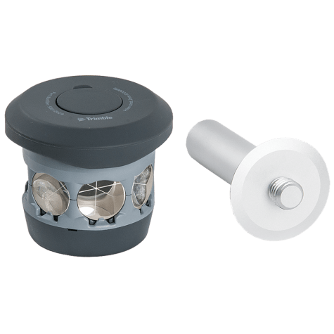 The 360 prism designed for Integrated Surveying with the Trimble R10 GNSS receiver. Compatible with all optical instruments. Request a quote - contact us. Accessory - RTS/RPT - 360 Prism includes height adapter to Trimble Standard target height (135mm).
 -
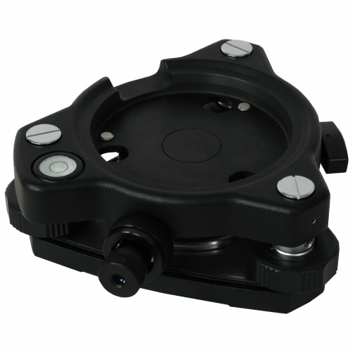 This tribrach has a focusing range of 1.5 to 50 feet (0.5 to 15 m) Black Weighs 1.85 lb (0.84 kg)
 -
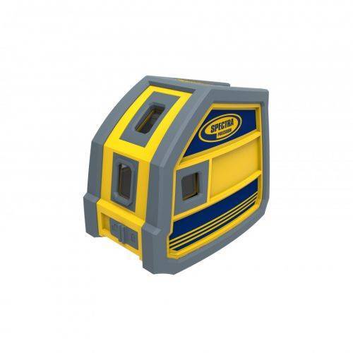
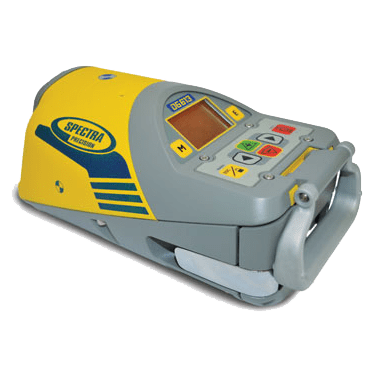 Compact and Powerful, the DG613 combines great performance with productivity.
 -
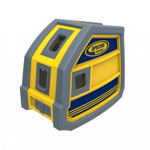
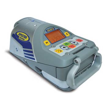 Completely waterproof, with large self-levelled grade range, the DG813 is so fast, so smart and so easy to use that it is an unsurpassed laser tool for pipe laying.
 -
 layout tools offer several benefits to general and interior contractors, electricians, plumbers and a variety of tradesmen.
 -
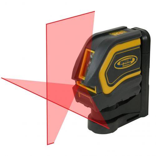
 This rugged red beam laser pointer offers several benefits to general and interior contractors, electricians, plumbers and a variety of tradesmen.
 -
 For interior building and remodeling, the LT20 laser tool is used for horizontal and vertical alignment, wall layout, acoustical ceiling installation and finish carpentry.
 -
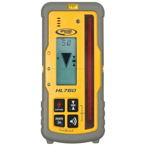
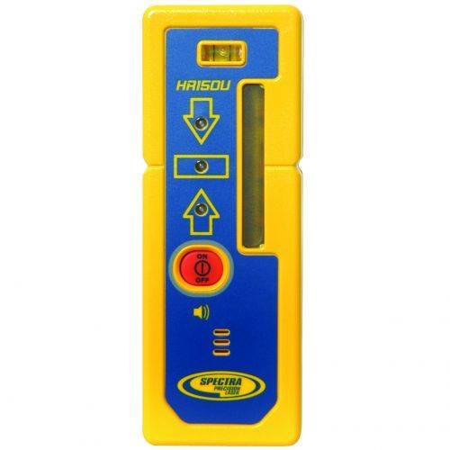 Featuring a tough composite material housing, the HR150 Laser Receiver can withstand a drop of up to 1.5 meters (5 feet) to a hard surface.
 -
 Highly versatile laser receiver for basic and advanced leveling and aligning applications
 -
 Works with LL400HV, HV302, GL412 and GL422N in automatic Grade Match and PlaneLok applications.
 -
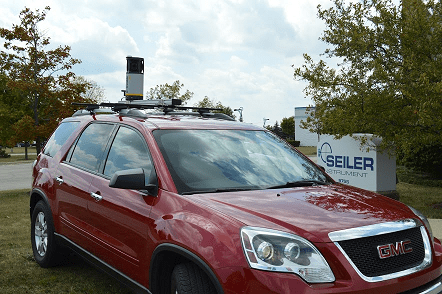
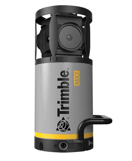 Contact us for details and special pricing! This demonstration unit has full warranty on hardware! The Trimble MX7 is a vehicle-mounted photogrammetric system equipped with six, 5 megapixel cameras, and Trimble Applanix GNSS and inertial geo-referencing modules. The Trimble MX7 can be deployed on vehicles of all sizes, letting you capture 30 MP geo-referenced images at highway speeds.
 -
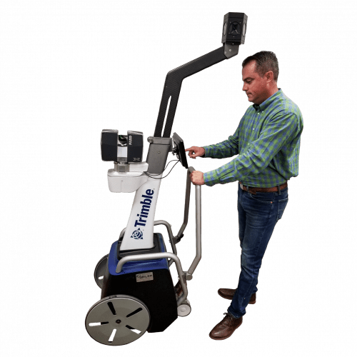 The Trimble Indoor Mobile Mapping Solution (TIMMS) is the optimal fusion of technologies for capturing spatial data of indoor and other GNSS denied areas.
 -
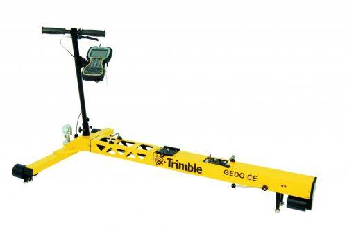
Trimble GEDO Track is a simple, integrated system to measure for precise adjustments, inspections and quality checks. In one operation, the Trimble GEDO captures the 3D coordinates of the track, together with gauge and cant. With its precision measurement systems, Trimble GEDO is suitable for conventional and high-speed rail construction. Contact us for more details and quote
KEY BENEFITS
- Reduce construction time and costs with immediate comparison of measured data to design
- Verify track geometry with accuracy and confidence. Precise optical positioning and a simple, self-contained trolley provide flexibility and reliable results
- Capture track 3D coordinates, gauge and cant in a single operation
- Import alignment design from digital or paper plans. Check design information before it goes to the job site
- Reduce time for documentation and acceptance. Capture adjustment and track acceptance data and quickly prepare reports for contractors and quality inspection
- Support for industry standard calculations including FAKOP® widening
- Satisfy reporting requirements with graphical and list form output of corrections for side and height correction plates
-
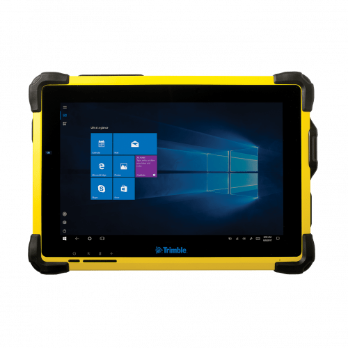 The Trimble® T10 tablet brings the advantages of fast computing power and a large screen to the field. Combined with integrated GNSS capabilities, the T10 is a powerful, rugged device created for survey fieldwork, mapping, and GIS data collection and at the same time supports demanding desktop applications.
 -
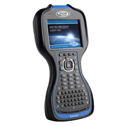 The third generation Spectra Geospatial Ranger™ Data Collector offers a large bright touch-screen, full alpha-numeric, easy to operate, keypad, and is packed with the features surveyors depend on.
 -
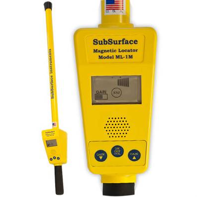 The ML-1 is one of SSI's longest-enduring and popular products for magnetic detection. Whether you're seeking corner markers (iron or steel), well casings, steel drums or septic tank handles, this is the go-to magnetic locator for you.
 -
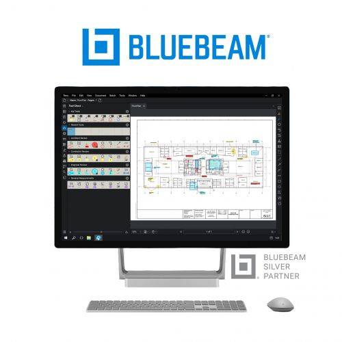 Bluebeam® Revu® is a PDF markup and editing software designed specifically for the AEC industry that allows for greater collaboration and efficiency—anytime, anywhere. Request a free 30-day trial or contact us for a quote.
 -
 Trimble® TerraFlex™ is a flexible and easy-to-use cloud-based solution for field data collection that enables you to capture standardized, consistent data on your Android device. Add Trimble Catalyst to your TerraFlex field workflows to access high accuracy positions when and where you need them, using only a lightweight antenna that plugs into your Android smartphone. Contact your local Seiler GIS professional for details or purchase your TerraFlex software solution here.
 -
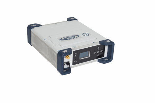
 Product Name: SP85 GNSS Single Receiver Kit with UHF 430-470 MHz 2W TRx Features:
- Patented Z-Blade™ technology
- 600-channel 6G ASIC
- Hot-swappable batteries
- Internal TxRx UHF radio
- L-band satellite capable GNSS antenna
- 3.5G cellular modem
- Built-in WiFi communication
- SMS and e-mail alerts
- Anti-theft technology
- Backup RTK
- RTK bridge
- eLevel technology
- Trimble® RTX correction services
-
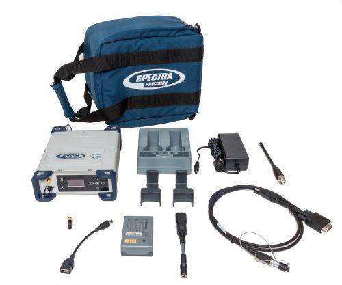
 Product Name: Spectra Precision SP90m, Survey, internal 410-470 MHz radio Features:
- Most versatile, modular receiver design
- Ultra-rugged design
- Patented Z-Blade technology
- 480-channel ASIC
- Dual GNSS antenna inputs
- Event marker input
- PPS output
- OLED display, keyboard, and Web UI
- Internal TRx UHF radio
- 3.5G cellular modem
- Built-in Bluetooth and WiFi communication
- SMS and e-mail alerts
- Anti-theft technology
- Backup RTK
- RTK bridge
- 2 MSS L-band channels
- Trimble RTX correction services
-
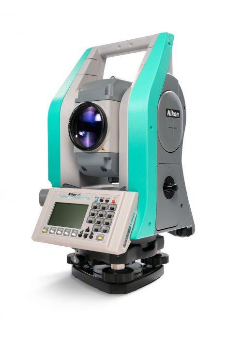
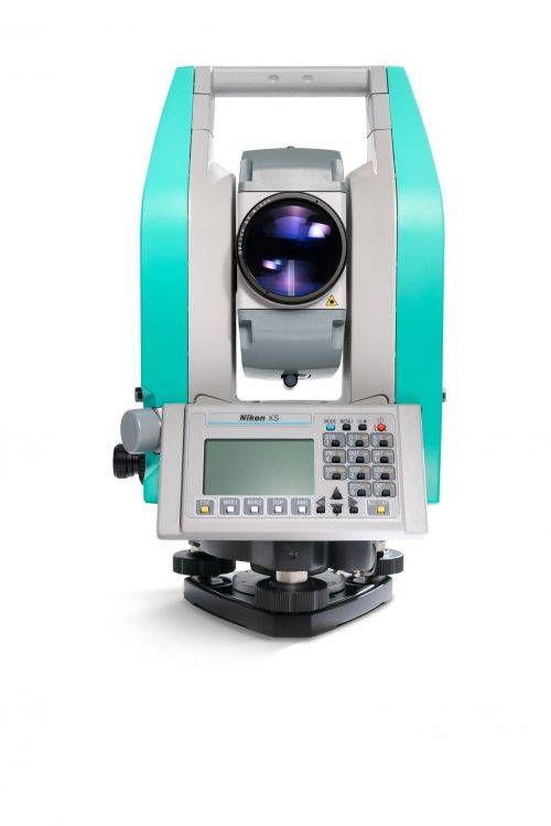 The Nikon XS mechanical total station is lightweight, compact and easy to set up making your job easier and more efficient. The onboard software ensures smooth, efficient workflow from the field to the office ensuring you the work done right the first time. Note: Sale price while supplies last. Product consisting of: Consisting of:
- 1x Nikon XS Main Unit 5" Total Station w/OP (weight 10 lbs)
- 2x Li-Ion Long-life Batteries
- 1x Tribrach
- 1x Plastic Carrying Case
- 2x Shoulder Straps for Carrying case
- 1x Universal Charger, Power Cord and Adapters
- 1x Rain/Dust Cover
- 1x Lens Cap
- 1x Adjustment Pin Tool
- 1x Allen Wrench
- Total weight on bundle above is 24 lbs. Box dimensions 21 ½” x 12 ¼” x 19 ¼”
-
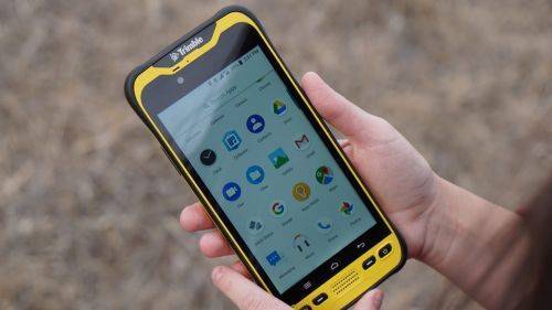
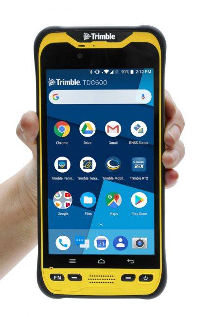 The Trimble® TDC600 GNSS Handheld Data Collector is a sleek, all-in-one rugged smartphone with a built-in professional GNSS receiver. Designed for ease-of-use in a wide range of GIS applications, the TDC600 helps you collect and retrieve highly accurate spatial information while staying in touch with the office—all with a single device. It’s the smart, productive way to collect data and communicate from the field. Contact your local Mapping GIS Sales Professional for a demonstration and full details. Customer FAQ's
 -
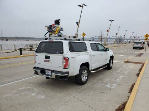
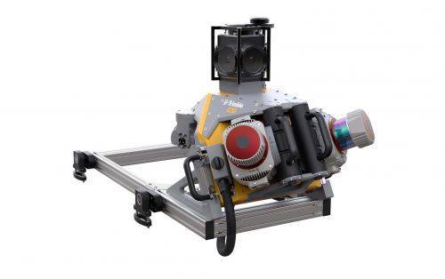 Trimble Mobile MX9 LiDAR Mapping Imaging Solution is for Large-Scale Scanning and Mapping Missions. The MX9 is a complete field-to-finish mobile mapping solution combining state-of-the-art, advanced hardware with intuitive field software and a reliable, efficient office software workflow. Contact your local Survey Sales Professional for a demonstration and full details.
