Products

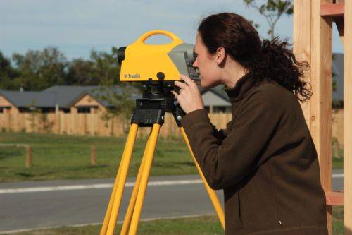
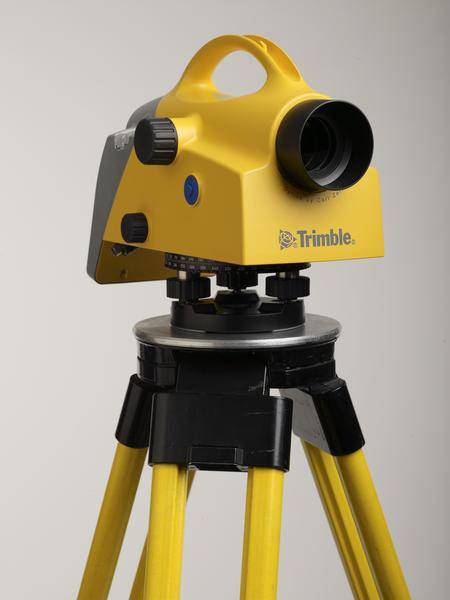
  • Trimble DiNi Level Digital Height measurement sensor - Trimble Quality and Accuracy for Measuring with Confidence.  Contact us to buy or learn more. 
    • Determine accurate height information 60% faster than with automatic leveling
    • Eliminate errors and reduce rework with digital readings
    • Transfer data to the office easily
    • Level Accuracy 0.3 or 0.7 mm
  • Spectra Pro field software

    Survey Pro provides you with a complete set of capabilities for all your survey projects. It’s fast, reliable and easy to use. Transfer data from Survey Pro to your laptop or PC and manage your jobs using Survey Office. Survey Pro software ships on Spectra Geospatial’s rugged line of data collectors providing unparalleled integration, data integrity, efficiency and ease-of-use. The features and functions of Survey Pro have been developed based on feedback from surveyors like you. Each new release of this software incorporates enhancements built on your field experience.  Contact us to learn more.   
  •   The Trimble® T7 tablet is purpose-built for demanding survey and GIS applications. Featuring a powerful processor, Windows® 10 OS, large memory and a modern user interface, the T7 is a fast, reliable field computer for surveyors and GIS workers alike. Capturing data, visualizing and manipulating maps, and running office applications out on the job site is easy with the T7—and it’s all packaged in a rugged, compact, highly portable device.  Contact us to learn more.       
  • Trimble SiteVision is a user-friendly outdoor augmented reality system that brings data to life so you can visualize and explore complex information with unrivaled accuracy.  Learn More Here.      
  • The Trimble® TX8 laser scanner sets new standards for performance and ease of use in high-speed collection of 3D data. Using a state-of-the-art blend of speed, long range and precision, the Trimble TX8 delivers high quality results in civil survey, industrial measurement, engineering and construction. It’s the scanner of choice for high levels of productivity, accuracy and flexibility. Contact your local Survey Sales Specialist to find out more. 
    The Trimble TX8 is designed for a broad array of uses and environments.   Typical applications include: ► Civil engineering ► Surveying ► Plant and industrial measurement ► Mining and quarries ► Urban areas ► Preservation and restoration ► Building and commercial construction ► Deformation monitoring ► Quality control ► Public safety and forensics
    Detailed Data Sheet
  • Screening Eagle Proceq GS8000 Subsurface Mapping System.

    The revolutionary Proceq GS8000 is the world’s most advanced subsurface mapping system, equipped with Stepped-Frequency Continuous-Wave (SFCW) technology and precise GNSS positioning. The true-ultrawideband antenna system and Swiss-made, optimized electronics deliver unparalleled resolution and penetration depth - at the same time.  Contact us to learn more via email here.

  • Proven reliable positioning 

    Depend on the Trimble® R580 GNSS system to keep you working with survey precision. Powered by the industry-leading Trimble ProPoint® GNSS engine, this everyday integrated receiver delivers greater productivity and reliable accuracy in more places.

    Benefits and performance

    With increased accuracy and reliability in difficult urban and rural environments, the Trimble R580 optimizes productivity using powerful GNSS technologies for maximum results.

    Productivity maximized

    The Trimble R580 harnesses Trimble ProPoint technology so you can survey with precision in difficult places, boosting field work productivity like never before.

    Trimble dependability

    With proven technology to guard against anti-spoofing and multipath issues, the dependable R580 provides confidence for every measurement and point you capture.
  • The Trimble X12 is a 3D laser scanner with the speed, accuracy, range and HDR imaging to capture the highest quality data available to produce impressive deliverables for demanding projects.
  • A 3D laser scanning system built with proven Trimble technologies, offering the range, accuracy, scan times and sensitivity you need to do more, better, and faster.
  • Trimble Perspective field software is specifically designed for in-field scanner control and complete registration when working with a Trimble 3D laser scanning system like Trimble X9 or X12.
  • Push the limits of productivity. Tackle large scanning datasets and workflows confidently with the Trimble® T10x tablet.

     
  • Trimble EMPOWER robotic radio module to connect with total stations. ONLY AVAILABLE FOR DELIVERY IN MO, IA, IL, IN, KY, MI, NE, and WI
  • TCU5 Model 2 rugged field controller elevates your productivity
  • Get reliable coverage no matter where you work with the Trimble® R750 modular GNSS receiver. Work efficiently and accurately, even in tough conditions, while receiving all the information you need, right at your fingertips.
  • The Trimble® R780 GNSS receiver allows you to choose your configuration and scale up by adding additional features. With robust GNSS positioning technologies, trust this ultra-durable receiver to boost your productivity and flexibility in any environment.
  • Wireless Tiltmeter Monitoring sensor with internal antenna.  Precise Movement Detection.
  • The Trimble® TDC6 data collector is a powerful, versatile and cost-effective field data collection solution for surveying and mapping professionals. Use the TDC6 standalone as a GIS data collector, paired with a GNSS receiver or as an onboard total station controller.

  • Unmatched GNSS Performance With Connected Workflows to Elevate Survey Productivity. The Trimble® R980 GNSS system unlocks peak accuracy and connectivity with proven Trimble GNSS performance, now more powerful than ever before. Trimble ProPoint® GNSS technology ensures robust data capture even in tough environments, while high-performance Trimble Inertial Platform™ (Trimble TIP™) IMU-based tilt compensation keeps you focused on the job at hand.


Go to Top